Re: Proposed addition of:
- St Canice’s Hospital (ref: ADD/150/13),
- St Canice’s Hospital Mortuary (ref: ADD/151/13),
- St Canice’s Hospital Catholic Chapel (ref: ADD/152/13),
- St Canice’s Hospital Church of Ireland Chapel (ref: ADD/153/13),
- St Canice’s Hospital attached red brick outbuilding(ref: ADD/154/13),
- St Canice’s Hospital red brick chimney (ref: ADD/155/13)
at Dublin Road County Kilkenny to the Record of Protected Structures.
Dear Sir/ Madam,
I am writing on behalf of the HSE in respect of the proposed inclusion of the above structures in the Record of Protected Structures appended to the Kilkenny City and Environs Development Plan 2014 to 2020.
At the outset I would advise the building referred to proposed protection ref: ADD/154/13 is not the building referred to on the map. This error needs to be corrected to ensure the correct building is recorded on the Record of protected Structures. To this end I would be grateful for confirmation of the correction.
While the HSE has no issue to the inclusion of these buildings, St. Canice’s has an extensive landholding which extends beyond the curtilage of the hospital complex. This landholding includes the HSE (South) Sub Regional Offices, a pitch and putt course, a farm and associated fields and a riverside woodland.
It is an objective of the Planning Authority to engage with the HSE in developing a Masterplan and Framework Plan for the hospital and other land and property in its ownership. Through this process it is envisaged most of the land and property which is surplus to HSE requirements will be sold off as development land. The development potential will evolve through the Masterplan and Framework Plan process.
To assist Masterplan and Framework Plan process it would be helpful to identify the curtilage of the hospital complex.
Please find attached a Plan which outlines what could be considered an appropriate curtilage for the hospital complex.
In particular;
The northeast boundary is defined by the Old Sion Road which is the extent of the landholding in this location.
The south east boundary is defined by the entrance access road and road to the farm.
The south west boundary is with agricultural lands. There is a tree belt along most of this boundary.
The north west boundary bounds open space and is tree and wall lined.
The open space in front of the main hospital building, which includes the tennis court, safeguards the setting of the main hospital building and is the only obvious land within the curtilage which is not immediate surrounding the building complex.
None of the lands outside the suggested curtilage are essential for the main day to day operation of the hospital. There is a therapy/ day services building in use which is located between the main hospital complex and the ring road. This building will become surplus to HSE requirements and has therefore been kept outside the curtilage. It is of no particular architectural merit.
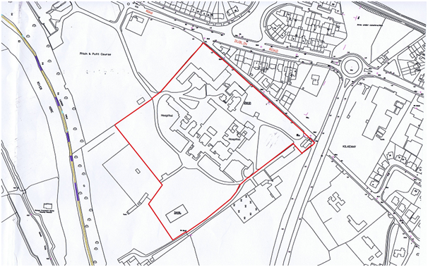
Suggested curtilage
I look forward to the Planning Authority’s response to this request.

