Submission in respect of the Draft Kilkenny City and Environs Development Plan 2014 to 2020
St. Canice’s Hospital and associated lands, Dublin Road, Kilkenny.
This submission follows meetings between representatives of the HSE and the Planning Department and an earlier submission in respect of the Kilkenny City and Environs Development Plan 2008 to 2014 concerning the future development potential of St. Canice’s Hospital and associated lands at Dublin Road, Kilkenny.
St Canice’s Hospital and its grounds comprise a significant land bank within the city and this is acknowledged in the Draft Plan.
The landholding extends to 22.311 hectares. At the northwest end of the landholding are HSE (South) sub regional offices housed in a two storey and basement office complex with associated parking.
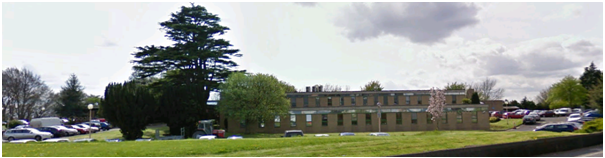
HSE (South) offices
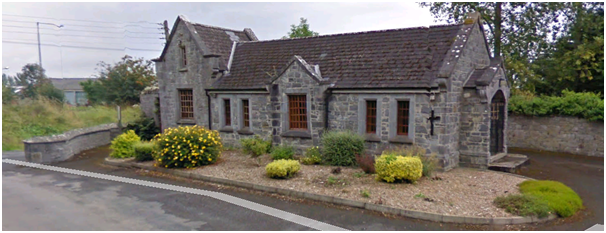
At the Northeast end of the site is St. Canice’s hospital. Historically an asylum, built in 1850, it now functions as a centre for social work and mental health services (non residential). There is an array of buildings around the main hospital including the mortuary chapel building located at the east most corner of the site with access onto the Old Sion Road.
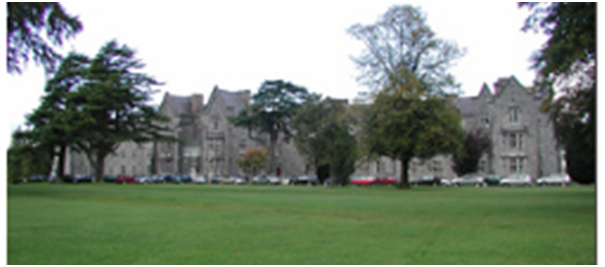
St. Canice’s Hospital
Mortuary
The remaining grounds are mainly open and include a pitch and putt course, open space, a former farm complex and a number of agricultural fields.
The entire western boundary comprises woodland set behind a high boundary wall. The Lacken Walk runs outside the boundary wall along the banks of the River Nore. The walk was recently ungraded by Kilkenny County Council and incorporates a board walk.
To the north, the landholding is bounded by the Dublin Road and Old Sion Road and to the east the city ring road.
HSE Policy
It is current HSE policy to evaluate its property portfolio, determine property requirements for the ongoing delivery of services and future service needs and to identify property that is, and will, remain surplus to operational requirements.
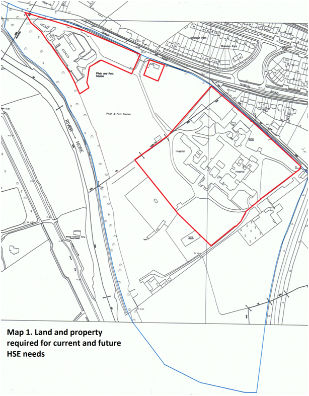
Map 1 attached highlights the land and property required for current and future HSE operational needs.
It is also HSE policy to identify the development potential of surplus property and dispose of it. The proceeds from the sale of surplus property and land will be used by the HSE towards the provision of future healthcare facilities and infrastructure requirements.
Draft Kilkenny City and Environs Development Plan 2014 to 2020
In the Draft Plan the HSE offices, pitch and putt, mortuary and some of the grounds around the hospital are zoned Recreation, Amenity and Open Space. The main hospital and associated buildings, former farm complex and open spaces are zoned Community Facilities while the open fields are zoned Agriculture.
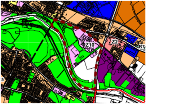
Draft Plan zoning extract
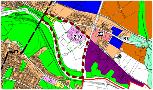
Zoning Objective Z10 applies to the landholding at St Canice’s Hospital. The objective is to work with the HSE and other relevant stakeholders in the preparation of a framework plan for the most appropriate land uses within the grounds of the hospital. Such a framework plan will take account of all existing land uses and develop a framework for the appropriate land uses and urban design criteria for the lands.
There are no protected structures within the landholding although the entire property is located within Lacken Architectural Conservation Area. Many of the older structures on site, including the main hospital, are listed in the National Inventory of Architectural Heritage.
However, St. Canices Hospital, the mortuary chapel, Catholic and Church of Ireland chapels and the red brick chimney are all noted in the Draft Plan as proposed for inclusion in the list of protected structures and this process in underway. A separate submission has been made to this process.
There are also many trees within the landholding listed in the Draft Plan Trees Survey (Appendix E of the Plan).
HSE requirements
Current and future requirements of the HSE are the retention of the sub regional offices and associated parking and St Canice’s Hospital and associated buildings. In addition the HSE is committed to facilitating the Lacken Pitch and Putt Club on the landholding, but not necessarily in the current location.
Surplus to requirements are most of the open grounds and fields surrounding and adjacent to the hospital, the mortuary, former farm complex and the riverside woodland. Also surplus is the therapy/ day services building adjacent to the ring road. While this building is currently in use, the services provide there can be relocated to the main hospital complex (see Map 1 attached).
Way Ahead
Through the Kilkenny City and Environs Development Plan 2014 to 2020 the HSE wish to highlight the development potential of its landholding through a commitment to prepare, in consultation with the Planning Authority, a Masterplan and Framework Plan and for an acknowledgement of the most appropriate uses on the surplus lands. The earlier submission by the HSE to the current Kilkenny City and Environs Development Plan 207 to 2013 suggested the surplus lands generally lent themselves to a mix of medium to low density housing.
A further aim of this submission is to remove the zoning objectives which apply in the Draft Plan to lands which may be surplus to HSE requirements. It is a concern that, once a Masterplan and Framework Plan have been prepared and future land uses agreed, that the retention of current Draft Plan zonings will present an impediment to future development unless the new uses detailed in the Masterplan happen to coincide with current zonings.
It is also an aim of this submission to re-designate the existing HSE sub regional office complex zoning from Open Space to General Business thereby reflecting the existing uses.
Removing some of the existing zonings is considered desirable for the following reasons:
Ø At present the pitch and putt course is zoned Open Space in the Draft Plan, but the facility could be relocated elsewhere on the surplus lands to allow the existing course to be developed.
Ø All of the lands within the landholding which were historically used for agricultural/ horticultural purposes are surplus lands. In the Draft Plan they are zoned Agriculture and Community Facilities. It is envisaged they will be developed in the future for a mix of residential and possibly open space (if the pitch and putt is relocated).
Ø The open ground to the north west of the hospital is zoned Community Facilities in the Draft Plan but is surplus to requirements and possibly lends itself to medium/ higher density housing in the future.
Ø The existing mortuary building is zoned Open Space in the Draft Plan but is surplus to requirements and will likely be used for alternative uses in the future.
Ø The existing therapy/ day services building adjacent to the ring road is surplus to requirements and zoned in the Draft Plan as Community Facilities. It potentially lends itself to demolition and redevelopment in conjunction with the adjoining land which is currently zoned Agriculture.
Ø The Open Space zoning in front of St Canice’s Hospital in the Draft Plan includes an area of land beyond the existing tennis court which is surplus to requirements and potentially lends itself to development in conjunction with lands currently zoned Community Facilities.
In the Draft Plan the HSE landholding is outlined and designated “Proposed Masterplan area”. This designation is welcomed and should be retained.
With the current Draft Plan zonings removed from those areas where future uses will be determined through the Masterplan and Framework Plan process, and with minor changes to Draft Plans zonings to reflect existing uses, the zoning map would appear as follows:
While it may not be desirable to be over prescriptive at this time in the precise location of actual uses which will evolve through the Masterplan and Framework Plan process, it is requested that the Development Plan text acknowledge the potential for a mix of medium/ high and low density housing. The Draft Plan recognises the need to provide a wide range of dwelling types and densities to meet the needs of the growing population. Proximity to local services such as shops, schools, local parks etc is acknowledged as important, particularly towards achieving the concept of the Compact City in which journeys by bike or on foot are no greater than 10minutes. The surplus lands at St. Canice’s meet these criteria and from a sequential perspective, the surplus lands comprise some of the closest undeveloped lands to the city centre.
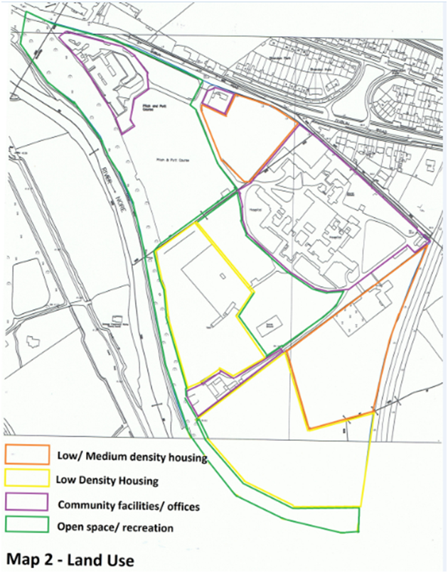
In the previous submission 10.5ha of land was identified as potentially suitable for residential development (Map 2). Of this 7 ha was considered to potentially lend itself to low density housing. If developed at an averaging of 10 houses per hectare (4 per acre) this land has the potential to provide 70 dwellings. The remaining 3.5 ha was suggested as suitable for medium/ higher density housing. Developed at an average density of around 30 per ha (12 per acre), this land would provide for a further 105 dwellings. Factoring in potential constraints such as proximity to protected structures, rights of way/ green infrastructure, trees, view corridors and buffer zones, a rough estimate would be that the surplus lands have the potential for 150 housing units or a population of 450. These figures may be of assistance in considering the potential of the surplus lands in the context of the Core Strategy.
Conclusion
The HSE have surplus land and property in the grounds of St Canice’s hospital which it is required to dispose of to fund future HSE facilities and infrastructure.
It is requested that the Draft Plan zonings be removed from the surplus and potentially surplus lands and that the Masterplan zoning be retained over the entire HSE landholding. Also, that the Draft Plan Open Space zoning over the existing HSE sub regional offices be changed to General Business.
It is further requested, in the context of the objective to prepare a Masterplan and Framework Plan for the HSE landholding, that it be acknowledged the surplus lands have the potential to provide a mix of low density and medium/ high density residential development.