Re: Preparation of the Draft Development Plan for Kilkenny City & Environs.
Dear Sir / Madam
On behalf of Niall and Angela Browne, Ayresfield, Granges Road, Kilkenny, owners of the land outlined in red on the site location map below, we wish to make a formal submission for consideration during the preparation of the Kilkenny City & Environs Development Plan 2014 – 2020 in the form of a request that the area zoned as Public Open Space in the site be reconfigured to optimise the use of the site both for the
provision of a residential development, and the creation of a better green route from Loughmacask through to the educational hub of the Granges Road.
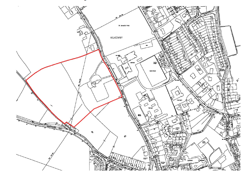
Site Location Map (OSI Map Excerpt)
The subject lands are located in the western environs of Kilkenny City within the development boundary of the City and Environs Plan. The lands are strategically located linking to both the Granges Road and the Lazybush Road, and will form an important pedestrian route from the future Loughmacask village centre through to the educational hub of the Granges Road.
The subject site of c. 5.1 ha (12.93 acres) forms a well-proportioned trapezoid shaped portion of land with frontage onto the Granges Road and the Lazybush Lane, to the east and west of the site. The land is bounded to the north by lands zoned for residential development and a single private residence, separated by a mature hedgerow, and to the south by the Ayrfield Residential Development, separated by a 2.0m high blockwork wall. The site itself is relatively flat and contains a number of significant protected trees, which are listed in the Kilkenny County Plan as trees number 261 to 276.
Kilkenny City & Environs Draft Development Plan 2014 – 2020
In the draft Plan, the zoning objective accorded to the site is of both residential and recreation, amenity and open space.
Recreation, amenity and open space
Objective: to preserve, provide and improve recreational open space.
Permitted uses: open space, sports clubs, recreational buildings, stands, pavilions, agricultural uses, halting site and public service installations.
Residential
Objective; to protect, provide and improve residential amenities.
Permitted Uses; dwellings, open spaces, places of worship, community facilities, halting sites, public service installations, childcare facility, nursing homes, bed and breakfast establishments, and guest houses, home based economic activity, parks and open spaces, playing fields, local convenience shop, nursing homes, and medical centre.
Open for Consideration; public house, hotel, restaurant.
Specific Objective of the lands in the Loughmacask LAP 2008 – 2014
Excerpt from Loughmacask LAP Movement Strategy and Open Space
Ayresfield House (LAP Excerpted Text)
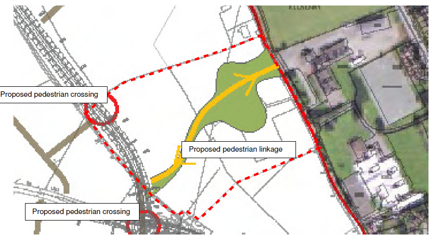
The grounds of Ayresfield House contain numerous trees typical of a parkland demesne landscape (Heritage Classification WD5). Throughout the trees, notable species include Lime, Beech and Horse Chestnut. Some of the trees are of considerable maturity and could be expected to support bat roosts. In addition to the above, the Ayresfield House site also offers a unique opportunity to provide a
pedestrian linkage between existing activities along Grange Road (such as existing schools) and the future village centre within the Loughmacask LAP area. Combined with the heritage value of the trees on site, the link would add to the overall qualities of the Loughmacask area.
Having regard to the above matters, it is Council Policy to:
o NH12 Seek the retention of the existing trees on the grounds of Ayresfield House. The Council may request that a bat roost survey be undertaken prior to considering future applications for development or tree felling.
o NH13 Provide pedestrian access through the Ayresfield House site between Grange Road
Reconfiguration Opportunity
There is an opportunity to reconfigure the zoning of the site to optimise the specific objectives of the Loughmacask LAP, and this submission seeks to demonstrate this.
Submission
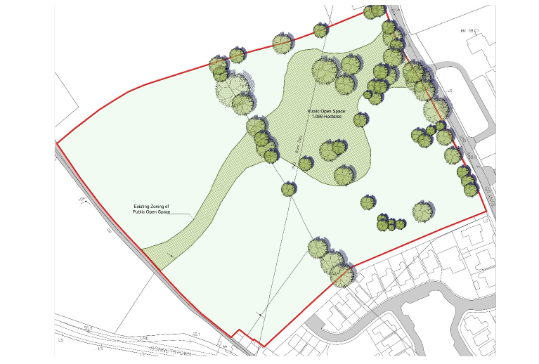
Existing Zoning information superimposed on Site survey

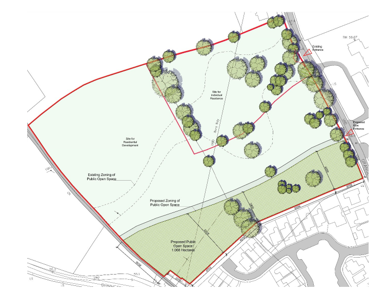
Proposed zoning information superimposed on Site survey
It is submitted that the subject lands should have the Public Open Space zoning relocated to the southern boundary of the site (and maintaining the same area of lands zoned for Public Open Space as per the existing zoning):
• The space of the public open space can have better linkages from the proposed Loughmacask public open space to the south of the site and the location of the pedestrian crossing.
• The proportion of the public open space in the proposed configuration opens out onto the Granges road educational campus and will be more accessible to the schools.
• The proposed zoning reconfiguration will enable the majority of the trees on the site to be retained into the ownership of a single residential property, which will in the long term ensure their protection and preservation. (In compliance with NH13 of LAP)
Traffic Implications:
Included in this submission is a traffic and transport report undertaken by Roadplan.
The conclusions of this report are as follows:
• The volume of traffic that would be generated by the development is small: 13 movements in the AM peak (the AM peak, rather than the PM, is the critical peak assessment period).
• The existing road network has spare capacity spare capacity sufficient to serve the proposed development.
• Significant additional road infrastructure is planned, in the form of the CAS and associated development roads, which will provide a significant increase in road capacity.
• The recent upgrading of set-down and parking at the Loreto Secondary School will have a positive impact on regulating traffic flow on Granges Road.
• The proposed access arrangement is a best-fit with the school access opposite and accommodates right- turning requirements. It is considered adequate for the numbers of turning movements associated with the development. The 3-acre quadrant in the northeast of the overall site is retained free of development in order to preserved mature trees therein. Therefore, the frontage within which an access to the 19 houses could be located is that which extends south from that 3-acre parcel.
• The repositioning of the public space zoning is not considered to have traffic and transport implications.
• The needs of vulnerable road users are catered for by the existing road network
Conclusion
The proposed zoning submission will have an overall beneficial effect in terms of the creation of a new pedestrian linkage from Loughmacask, it will ensure the protection of the protected trees, and it has no negative traffic implications Granges Road.
It is requested that this submission be taken into account in the preparation of the Kilkenny City & Environs
Development Plan 2014 – 2020.
Yours sincerely
_____________________
Mark Kennedy
REDDY ARCHITECTURE + URBANISM
Encl.
Existing Zoning Map Scale 1:1000
Proposed Zoning Map. Scale 1:1000
Existing Zoning Map Scale 1:2500
Proposed Zoning Map. Scale 1:2500
First Name:
Niall and Angela
Last Name:
Browne
Name of Organisation or Group:
Reddy Architecture
on Thu, 22/08/2013 - 12:00am admin

