Introduction
This is a submission on behalf of the Phelan Family of Conahy, Ballyragget, Co. Kilkenny to the County Development Plan for 2014 – 2020. It is in relation to the zoning of areas which will be deemed ‘Preferred’ in the Wind Energy Development Strategy and in particular to the family land in Conahy outside Ballyragget. Figure 1 below shows the location of these lands on an ordnance survey map. This submission details the reasons why this land and the surrounding areas should be designated suitable for wind energy development.
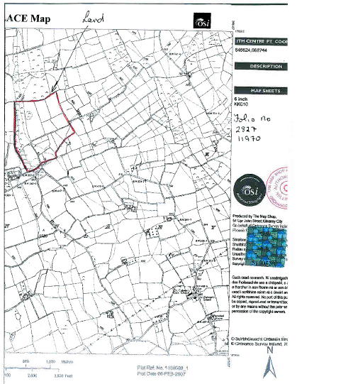
Figure 1: Family Land Location
Renewable Energy
Energy costs in Ireland are rising exponentially due to our reliance on fossil fuels and industries with high energy usage are facing constant inflationary cost pressures. Aligned with this, global governments have developed climate change policies to arrest greenhouse gas emission levels and the effect they are having on the planet. As part of the EU target under the Kyoto Protocol, Ireland is legally bound to meet the greenhouse gas emissions reduction target. Consequently, the energy industry in Ireland is set to change significantly to meet its Kyoto obligations by reducing greenhouse gases and improve security of supply. The Irish government has committed to a 40% penetration of renewables to the electricity market by 2020. The vast majority of this will be supplied by wind power. Ireland due to its location on the westernmost point of Europe is ideally located to optimise the opportunities offered by wind energy. In turn, individual governmental agencies including county councils are committed to supporting this strategy under EU Directive 2009/28/EC.
Location
Figure 2 below shows the land within the proposed zoned area. The enclosed area ranges in altitude from 150 to 250 metres above sea level making it suitable for wind energy development with average wind speeds in the 7.5 to 8.5 metres per second range. The map also highlights the ridge line along the altitude peak line and the zoned area is south west of this line. Ideally, the zoned land would extend eastwards over this ridge but this may prove sensitive from a planning perspective. We would suggest that the proposed zoned area would represent the minimum area required and should be extended where feasible. The area takes in the townlands of Conahy, Donaghmore, Toormore, Toorbeg and Kilmacar.
The area is approximately 4km south east from the town of Ballyragget which has a significant electrical load requirement from the town and surrounding areas. Significantly, the Glanbia food group has its headquarters and manufacturing plant in the area which also requires substantial power. Locating energy generation at or close to consumption has significant benefits. Transmission losses along electrical cables accounts for 10% of Ireland’s energy requirements and this can be eliminated or significantly reduced by strategic generation location. Distributed generation, as it’s known, is a growing industry and proves to be a win-win for governments as it increases the amount of renewables on the grid and relieves the pressure on the transmission system. In the US, 25% of all renewable energy projects from 2002 - 2010 were distributed generation.
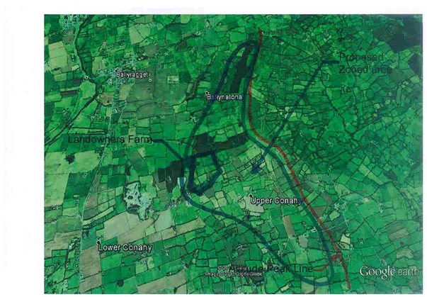
Figure 2: Proposed Zoned Area
Winds in Ireland are predominantly from a south western perspective and this location provides open and clear views in that direction. This site would receive substantial wind streams from all southern and western perspectives and provide energy to power wind generation turbines.
One of the major barriers to increasing the amount of renewables on the system is that most of the high altitude areas are remote and the national grid is too far away and therefore too expensive to extend to these areas. The infrastructure is already in place due to its central location and a new 110kV circuit is planned adjacent to the existing ESB Ballyragget 38kV substation. With this investment in place, it makes this location a prime area for wind development.
Economics
Wind energy developments will also bring employment to this local area during construction and during its operating lifecycle. It also provides income to local landowners and provides diversification to dwindling farm incomes.
Planning Considerations
Various aspects are taken into consideration when reviewing if wind energy developments are appropriate to certain landscapes. These include;
Landscape Character Assessment (LCA)
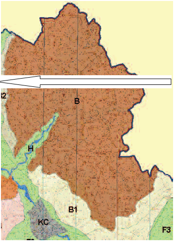
A Landscape Character map of Co Kilkenny was completed indicating significant landscape features with the extent, boundaries and
components of each area highlighting sensitivity and planning policy. The nearest LCA to the proposed zoned area is the Castlecomer Plateau and as can be seen from the map below in Figure 3, the proposed zone is immediately to the west of the LCA.
Figure 3;
Map of Castlecomer Plateau LCA - Position of Proposed Zoned Area is to the West of this area and outside of LCA.
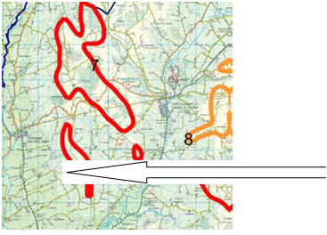
Drawing reference to the Kilkenny Draft County Development Plan, Figure 10.2 details the Wind Energy Development Strategy layout of the county highlighting 22 areas of the county where wind speeds are in the region of 8 metres per second. These areas are then spilt into what may be considered ‘preferred’, ‘open for consideration’ and ‘unsuitable’. Figure 4 below is an extract from this map with area 7 highlighting the sections with wind speeds higher than 8 metres per second in this portion of north Kilkenny. There are 3 high altitude areas within this area and the landowners farm and proposed zoned area is to the southwest of the most southern area as highlighted.
|
In the draft plan, area 7 is marked ‘unsuitable’ as it is in the Castlecomer Plateau LCA but as shown in Figure 3, the proposed zone as highlighted in Figure 2 is just to the west of this LCA. As mentioned earlier, the proposed zone is the minimum area we would propose and suggest it should include some if not all of the ‘teardrop’ in the southern area of section 7 from Figure 4.
Prominent Ridge Lines
The ridge line from Figure 2 runs from 250 metres above sea level south easterly to 150 metres. This area of north Kilkenny has higher ridges in excess of 300 metres both to the north towards Castlecomer and to the west beyond Lisdowney, so we would argue that this ridge line would not be prominent within the general landscape.
Settings
Due to the local landscape highlighted above, the only urban setting with a view of the proposed zoned area would be Ballyragget. There is a consented windfarm near Lisdowney to the west which will be at a higher altitude and would also be clearly visible from Ballyragget. We would argue as the proposed area is currently drawn below the ridge line, it would be far less intrusive visually.
Tourism & Heritage
From the draft plan, reasoning for designating area 7 as ‘unsuitable’ was given as views from Ballyouskill, Ballyragget and Castlecomer. As detailed above, there will be no visibility from Ballyouskill or Castlecomer as higher ground exists at over 300 metres between both places and the proposed zoned area. Obviously, due to local topography, these views relate to the northern portion of area 7 from Figure 4 and should not impinge on the ‘teardrop’ portion. Views from Ballyragget were dealt with in the Settings section.
Existing Windfarms
As mentioned, there is a consented windfarm in the locality to the west of Lisdowney at Kilcomman Cross. Although it will be visible either side of Ballyragget, cumulative effect will not be an issue as approx 10km will separate them.
Adjoining County
The draft plan highlights the Laois designation on the other side of the border. This may be relative to the northern portion of area 7 but due to local topography and in excess of 10km in distance from the border to the proposed zoned area, we would argue that it is irrelevant to the southern portion of area 7.
Summary
To leverage Ireland’s natural resources, we need to position wind turbine sites in areas where the available energy can be maximised, while paying due regard to environmental considerations. The area we are proposing to be zoned ‘preferred’ meets the six conditions outlined in Planning Considerations. Aligned with this, the advantages of generating energy close to consumption have been clearly defined and the fact that the electrical transmission and distribution system is in place and about to be upgraded, further strengthens the case. We look forward to discussing the various components of this submission with you and hope to reach a conclusion that meets the requirements of Kilkenny County in particular and the wider national interest in general.

