RE: SUBMISSION TO DRAFT KILKENNY CITY & ENVIRONS DRAFT DEVELOPMENT PLAN 2014-2020 LANDS AT LOUGHMACASK AND CROKER’S HILL, KILKENNY
Dear Sir / Madam,
We Ryan Nowlan Consulting Ltd., Merchants Hall, 25 – 26 Merchants Quay, Dublin 8 make this submission in relation to two sits which form a strategic landbank with a combined area of over 23 hectares (ha.) in extent lying to the north west of Kilkenny City within the boundaries of the Draft Kilkenny City and Environs Draft Development Plan 2014 -2020.
The lands are located at Loughmacask located within Kilkenny County Council administrative area and Crokers Hill located within Kilkenny Borough Council administrative area. These lands are in receivership and therefore this submission is made on behalf of the Joint Receivers appointed over certain assets of GMB Construction, including the subject lands. The Joint Receivers are Paul McCann and Patrick Dillon of Grant Thornton, 24 – 26 City Quay, Dublin 2.
Grant Thornton are experienced Property Receivers and recognise their responsibility to protect and enhance the value of the subject lands through identification of sustainable development strategies for each area lying within the Western Environs Local Area Plan (LAP) and within the Neighborhood of Loughmacask as identified on the Draft Plan Map 3.1 Core Strategy Map.
1.0 PURPOSE OF SUBMISSION
The purpose of this submission is to highlight the importance of the subject lands as strategic landbank central to the delivery of the Core Strategy of the current and Draft City and Environs Development Plan. We therefore request that the development potential of the lands as currently set out in the Development Plan be continued in the Development Plan for the period 2014 – 2020. These are development lands that by virtue of location and extent are essential to delivering the land use policies and objectives of the current Development Plan, LAP and Draft Development Plan that in turn, will deliver the essential community, residential and recreational needs for the critical mass population of the South East Region Hub City that. For the most part we acknowledge that the Draft Plan builds on the policies, studies and advances in infrastructural provisions over the current Plan period which is welcome. However, we conclude with a request for alteration to Figure 7.2 Green Infrastructure and Rights of Way Draft Plan Map as we have identified its conflict with Draft Development Plan land use zoning and development objectives.
1.1 Format of Submission
We have inspected the Draft Kilkenny City and Environs Development Plan 2014 – 2020 Written Statement, Appendices, Environmental Reports and Maps and make this submission for the above mentioned lands in the following format:
1.0 Purpose of Submission
2.0 Subject Lands Location and Description
3.0 Development Context of Subject Lands
4.0 Conclusion
2.0 SUBJECT LANDS LOCATION AND DESCRTIPITON
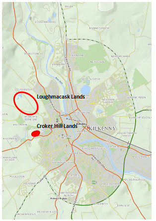
Figure 1 Approx. Location and extent of Subject Lands
The subject lands consist of two distinct parcels of land. The larger landbank is over 40 acres (20.5 ha.) located in the centre of Loughmacask. This site is triangular in shape tapering in its south eastern corner at the current junction of Bonnetstown Road and the local Tullaroan Road (Bothar Na Gráinseach) which themselves from the southern and northern boundaries of the subject lands respectively. It is noted that according to figure 10.2 Figure 10.2 Street Hierarchy of the draft Plan this local road and the aforementioned junction forming the south eastern tip of this site are on the North Link Road (Medium Term) alignment. The northern end of the subject lands are currently under pasture and according to Draft Plan figure no. 7.1 Natural Heritage are part distinguished by the presence of a pNHA (Lough Macask).
The smaller of the two sites is nearly 3 ha. In extent and is located at Crokers Hill with a north to south orientation onto the Circular / Kennyswell Road (R695) opposite Rothe Terrace.
3.0 DEVELOPMENT CONTEXT OF SUBJECT LANDS
We have compared the development objectives for the subject lands under the current Development Plan 2008 – 2014, including Variation no. 1 Core Strategy that was adopted in July 2011. That Variation was wide ranging and included amendments to the Development Plan Strategy, Housing Strategy and Flood Risk Assessment with subsequent amendments to the Loughmacask Local Area Plan (LAP) 2008 – 2014.
We note that the Loughmacask LAP was extended to run until 2018 by resolution of both Kilkenny Borough and County Councils in March of this year. By extension, we recognise that the Draft City & Environs Development Plan 2014 – 2020 accords with the provisions of the extant LAP.
3.1 Loughmacask Lands
The subject lands are the lynchpin of the Loughmacask LAP forming as they do the central area of the LAP and by extension, the centre of the Loughmacask Neighborhood primary location for planned expansion of the City, as recognised in the Core Strategy of the current and Draft Development Plans a.
Land use zoning objectives in the current and Draft Plans show that the subject lands deliver the Loughmacask neighbourhood centre, residential accommodation and a significant degree of amenity in leveraging the Lough Macask proposed Natural heritage Area (pNHA) as a locus of green routes punctuating the City Environs. The pNHA itself and conjoined green corridor are protected as open space under current and proposed land use zoning.
The subject lands benefit from a number of extant planning permissions related to facilitation works and actual built accommodation development. Most significant is a planning permission for 223 residential units and works to the pNHA and associated lands to create amenity space granted under an Bord Pleanála Ref. PL10.238542 following third party appeal notification of decision to grant permission under Kilkenny County Council Reg. Ref. 10/15. This planning permission granted on 17th January 2013 accord the provisions of the LAP and Development Plan and was facilitated by improvements in infrastructural road and services capaciities since the designation of the lands for development.
3.2 Crokers Hill Lands
The Crokers Hill lands due to their linear shape running along Circular Road in the midst of existing, mature and newer residential inner suburban development present an ideal infill site. Once developed, these lands will fully realise Crokers Hill role by creating a cohesive cluster neighbourhood within the inner suburbs of the City. These lands also have a significant opportunity to deliver high quality residential amenity for future residents lying as they do on the edge of designated green space surrounding the Breagagh River.
The Crokers Hill lands are zoned residential in the current Plan and retain that land use zoning in the Draft Development Plan.
During the review of the Draft Development Plan however, it is noted that he subject lands are designated as ‘Key Green Infrastructure’ in Figure 7.2 Green Infrastructure and Rights of Way. We submit that the designation of the entire of the area between the Breagagh River and Circular Road at this location conflicts with the current and Draft land use zoning objective of the subject lands.
When one compares Figure 7.2 Green Infrastructure and Rights of Way to Figure 3.3 Zoning Objectives Map of the Draft Development Plan this conflict is highlighted and it is noted that the remaining areas identified as ‘Key Green Infrastructure’ on Figure 7.2 are designated as land sue zoning ‘Recreation, amenity and open space.’ We request that Figure 7.2 of the Draft Development Plan be therefore amended to reflect the land use zoning of the subject lands. Figure no.2 below repeats an excerpt of the Crokers Hill area from Figures 3.3. and 7.2 to illustrate the Draft Plan conflict in mapped objectives.
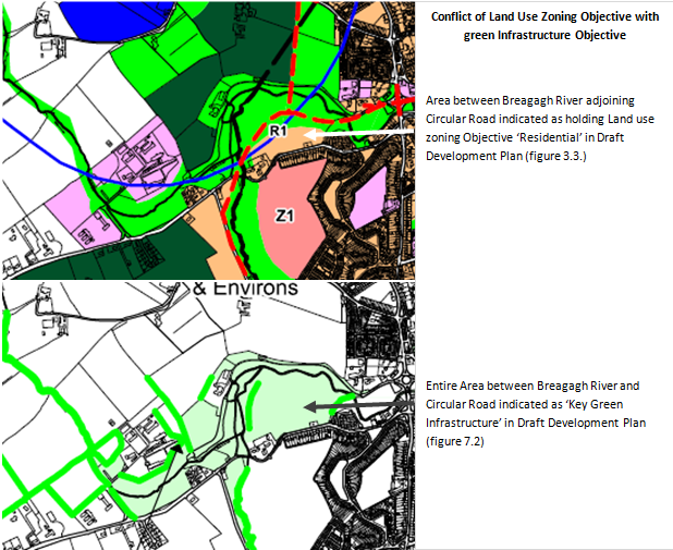
Figure 2 Comparison of Crokers Hill Excerpts of Figure 3.3 Zoning Objectives Map and figure 7.2 Green Infrastructure and Rights of Way of Draft Kilkenny City & Environs Development Plan 2014 – 2020.
The majority of these lands also benefit from planning permission granted 17th January 2008 for residential development following 3rd party appeal under PL62.221535 which upheld a decision to grant permission. Residential accommodation is to be delivered in a combination of apartment blocks and terraced and detached housing. Nine blocks were originally proposed but over the course of consideration of the planning application and appeal 1 no. block was removed and minor modifications were made to the layout of the scheme e.g. removal of parallel car parking spaces along Circular / Kennyswell Road. An extension of duration of planning permission was recently considered and granted under Reg. Ref. 13/5 in May 2013.
Having reviewed the Draft Plan Written Statement Chapter 6 Recreation we note that at subsection 6.1 it is the Councils intention to “…endeavour to make provision for a hierarchy of parks, open spaces and recreation areas within the city so that the population can participate in a wide range of active and passive recreational pursuits within easy reach of their homes and places of work.” This view is supported by a stated objective “The Council shall seek the preservation and improvement of amenities and recreational amenity facilities, and shall facilitate and provide for the extension of recreational amenities in the city where appropriate, and subject to environmental, heritage and financial considerations.”
However, we also note that the Breagagh River Corridor is described for protection as part of the series of Regional and City Parks and Corridors at subsection 6.1.2.1 of the Draft Plan and annotated on Figure 7.2 of the Draft Plan.
We support these amenity policy objectives and believe the that subject lands can promote their realisation where the existing and draft land use zonings and established development potential as enshrined in granted planning permissions is protected. As such we repeat our request that figure 7.2 is amended at Crokers Hill to reflect the underlying extant residential land use zoning objective by the reduction of the ’Key Green Infrastructure’ designation.
4.0 CONCLUSION
Section 3.2 Distribution of Housing Land Requirement of the Draft Plan Written Statement sets out the evolution of sustainable development policy “It has been a long established principle in the Kilkenny City Development plan that the expansion of the City would occur in the environs in phased blocks. This philosophy has been continued through development plans since 1986.”
The Draft Plan continues to map this evolution referencing the Core Strategy, the 2008 Development Plan preceding the current Plan and Loughmacask and Western Environs LAPs. These Plans and strategies have established and promoted the phasing principle of focusing on ‘Neighbourhoods’. There are 4 main Neighbourhoods; Loughboy/Archerstreet, Newpark Upper/Eastern Environs, Poulgour/Wetlands/Western Environs and Loughmacask. The subject lands lie within the Loughmacask Neighbourhood. The Draft Plan sates that “As Loughboy/Archerstreet and Newpark Upper are substantially built out, the two remaining areas of the Western Environs and Loughmacask will be the focus for greenfield development over the plan period. Both of these areas were the subject of Local Area Plans.”
Having regard therefore to the phased Neighbourhood development principles of the Plans it is submitted that together the lands the subject of this submission, by virtue of their location, extent and established identification as development lands are a strategic land bank necessary and central to the sustainable development of Kilkenny City and Environs in accordance with the immediate needs for expansion of the City under the Core Strategy within the current and Draft Plans.
We have compared the development objectives for the subject lands under the current and Draft Development Plans and also set out the planning history of the lands. For the most part we acknowledge that the Draft Plan builds on the policies, studies and advances in infrastructural provisions over the current Plan period which is welcome.
However we have identified that there is a conflict in the mapped objectives of the Draft Development Plan Figure no.s 3.3. and 7.2 where lands at Crokers Hill that hold a residential land use zoning and have recently been granted an extension of duration of planning permission for residential development are indicated as ‘Key Green Infrastructure’. We formally request therefore that Figure 7.2 accord with the arrangement of land use zoning objectives in Draft Plan Figure 3.3 and be amended accordingly to avoid confusion and curtailment of the development of the Crokers Hill lands in the future.

